A.50 Newport, DE
A.50.1 Contacts
Regulatory Contact: US EPA (Region III)
EPA ID# DED980555122
Site Contact: Anthony Iacobone
A.50.2 Summary
|
Environment: |
Tidal and non-tidal freshwater wetlands and the Christina River |
|
Scale: |
Full |
|
Contaminants of Concern: |
Cadmium, lead, and zinc (drivers for remedy) |
|
Source Control Achieved Prior to Remedy Selection? |
No |
|
Final Remedy: |
Capping, wetland remediationThe act or process of abating, cleaning up, containing, or removing a substance (usually hazardous or infectious) from an environment., restoration and monitoring, waste consolidation, excavation, sediment disposal, and dredging |
|
MNR viewed as a success? |
Not applicable |
A.50.3 Site Description
The E.I. du Pont de Nemours & Co. Inc., (Newport Pigment Plant Landfill) Superfund Site (a.k.a. DuPont-Newport Site) is located in the Town of Newport, New Castle County, Delaware (Figure 1). It is an approximately 120-acre site that includes the location of a paint pigment production facility (Ciba Specialty Chemicals or CibaSC), a former chromium dioxide production facility (DuPont Holly Run), two industrial landfills (the north and south landfills) separated by the Christina River and baseball diamond owned by DuPont situated just northwest of the paint pigment plant across an Amtrak railroad. The site also includes portions of the Christina River.
Sediment impacts, and in some cases surface water impacts, at the site were a result of the following: 1) precipitation1) The formation of a solid in a solution or inside another solid during a chemical reaction or by diffusion in a solid; or 2) rain, sleet, hail, snow and other forms of water falling from the sky. of some groundwater contaminants as they discharged to the Christina River or wetlands; 2) direct dumping including breached dikes at one of two landfills located on the south side of the site; 3) erosion/surface water runoff which in all likelihood carried contamination from a northern disposal area to the Christina River during the time the landfill was operational; and 4) incoming tides carrying contamination from the northern wetlands. Sediment samples were collected from wetlands located on the north side of the site (including a drainage way) and the south side of the site (including a south pond), and the Christina River.
Sediment contaminants included arsenic, barium, cadmium, chromium, copper, lead, mercury, and zinc. Additionally, groundwater seeps to surface water included aluminum, cadmium, chromium, copper, iron, lead, mercury, zinc, 1,2-dichlorobenzene, chlorobenzene, 1,4-dichlorobenzene, tetrachloroethene, and trichloroethene.
Tidal wetlands exist at the site on both sides of the Christina River adjacent to the landfills. The northeast corridor of the Amtrak Railroad runs along the northern edge of the site, and a junk yard exists immediately to the southwest of the site.
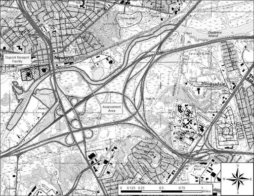
Figure 1. Site location map.
Currently, CibaSC operates a paint pigment plant at the site and DuPont operates a groundwater pretreatment plant. Two landfills serve as long-term containment of waste, and restored wetlands provide ecological habitat.
The DuPont- Newport site, was originally built during the period of 1900 to 1902. The plant was owned and operated by Henrik J. Krebs and manufactured Lithopone, a white, zinc- and barium-based inorganic paint pigment. In 1929, DuPont purchased the plant and continued to produce Lithopone. Lithopone production ceased in 1952 because of reduced demand for the product. DuPont had begun to produce different organic and inorganic pigments by this time along with other miscellaneous products at the site, including purified titanium metal, blue and green copper phthalocyanine pigments, red quinacridone pigment, high purity silicon, thoriated nickel and chromium dioxide.
During the 1970’s DuPont expanded its chromium dioxide production operation by building the DuPont Holly Run plant. In 1984, the pigment manufacturing operations were sold to Ciba-Geigy Corporation (now CibaSC), but retained the chromium dioxide production operations. From 2000 to 2001, DuPont shut down the Holly Run plant and dismantled most of it.
The former DuPont Holly Run plant and the CibaSC plant were built on fill material placed over low-lying farmland. Most of the fill material underneath the CibaSC plant, and a small portion of the former DuPont plant, is contaminated with heavy metals such as cadmium, lead, barium, and zinc as a result of past disposal operations and poor raw material storage and handling practices. Waste and off-specification products were disposed of in the north and south landfills prior to CibaSC ownership.
The north landfill was constructed by disposing miscellaneous fill behind an artificial berm along the Christina River. Wastes, including Lithopone, other organic pigments, chromium, and miscellaneous materials such as thoriated nickel were disposed of in the north landfill from 1902 to 1974. The maximum waste depth in the landfill was approximately 20 to 25 ft with no bottom-liner system constructed prior to fill placement. Drums containing thorium-232/nickel alloy and processing materials were disposed in this area from 1961 to 1966 and are buried about 10 ft below the top surface of waste fill. Fill included trash, steel drums, concrete rubble, steelwork, and artificial marble. Waste from the landfill migrated into the adjacent wetlands and the Christina River.
The south landfill was used for the disposal of large quantities of Lithopone wastes, which were pumped through a pipe on the river bottom and discharged to a diked area in a wetland. The bottom of the south landfill is also unlined and some of the waste is currently in the water table. The south landfill operated from approximately 1902 to 1953.
During the late 1970’s and early 1980s’ groundwater was sampled from on-site monitoring wells. The results indicated elevated levels of heavy metals and volatile organic compounds (mainly tetrechloroethene and trichloroethene) in groundwater. During August 1988, DuPont entered an ACO with the EPA and agreed to perform an RI/FS for the site. This study included collection of groundwater, soil, sediment, and surface water (both river and wetlands) samples. Although the site was originally included on the NPL because of groundwater contamination caused by the north landfill, the RI/FS found that the Christina River and the adjacent wetlands were contaminated as well. Some areas showed significant impacts to the ecosystem, although other areas had only minor impacts. The site was added to the NPL list in February 1990 and a ROD was issued in August 1993.
In 1994, DuPont submitted a Remedial Design/Remedial Action Work Plan, as directed by the ROD and the ACO. Incorporated in this work plan was an initial value-engineering assessment that identified the most cost-effective implementation of remedies specified in the ROD that are also protective of human health and the environment. Pre-design investigations were outlined for the north and south wetland areas and the Christina River to delineate areas for sediment removal. A phased sampling strategy was developed and implemented to fulfill the ROD requirements. The ROD required delineation of three metals (cadmium, lead, and zinc) that were associated with the pigment manufacturing at Newport. Two sets of criteria were provided in the ROD: EPA site-specific sediment cleanup criteria (SSCC) and apparent effects threshold values (AETs). Sediment concentrations exceeding the SSCC in the sediments would need to be excavated while sediment concentrations below the AET values could be left in place. Those concentrations detected between these two criteria may have required additional investigation.
CSM summary: As part of the RI/FS, EPA conducted a human health risk assessment and an environmental risk assessment. Most of the risks at the site were to environmental receptors, especially aquatic life. The environmental risk assessment determined that several areas of the north and south wetlands and the Christina River warranted remediation based on the review of all available data, most importantly, that of sediment toxicity tests, benthic studies, and sediment bulk chemistry data.
A.50.4 Remedial Objectives
Based on the potential impact to human health and the environment, the EPA determined that the following areas of the site warranted remediation:
- North landfill including the drainage way: This area continually released contaminants to the groundwater in the fill and/or Columbia aquifers, which affected ground-water discharge areas. One of the areas affected by the discharge was the Christina River which had exceedances of AWQC or state water quality standards or state water quality standards (State WQS) exceedances and sediment, which exhibited unacceptable environmental impacts. The north drainage way, which also received discharges, exhibited extreme impacts to ecological receptors. However, EPA determined that treatment of the contaminated sediments in the north drainage way, due to site-specific conditions, was not feasible. EPA determined that both engineering and institutional controlsNon-engineered instruments, such as administrative and legal controls, that help minimize the potential for human exposure to contamination and/or protect the integrity of the remedy. at the north landfill and associated wetlands would be protective enough for human health and the environment.
- South landfill and associated wetlands: This area continually released contaminants to the groundwater in the fill zone and/or Columbia aquifers, which affected groundwater discharge areas. The two discharge points were the river and the south wetlands, which had AWQC and State WQS exceedances and sediment which exhibited unacceptable environmental impacts. Future subsurface maintenance or construction activities would have resulted in unacceptable risk to humans. Part of the wetland area exhibited unacceptable environmental impacts including low benthic density and poor benthic diversity (a high percentage of pollution tolerant species).
- Christina River: Some of the sediments in the river exhibited unacceptable environmental impacts. Additionally, AWQS and State WQSs for several site-related contaminants, including cadmium, lead, and zinc were exceeded in the vicinity of the site.
- CibaSC plant and small portion of the DuPont holly Run plant: Exposure to surface and subsurface soils caused unacceptable risks to humans. This area continually releases contaminants to the groundwater in the fill zone and/or Columbia aquifers, which affects groundwater discharge areas. One of the discharge points affected is the Christina River which had AWQC or State WQS exceedances and sediment which exhibited unacceptable environmental impacts.
The remedial alternatives in ROD addressed contaminated soils, sediments, surface water, and groundwater at the site. The RAOs specific to sediment included the following:
- Prevent exposure to contaminated sediments.
- Prevent exposure to highly contaminated surface water.
- Prevent further degradation of the environment caused by the discharge of contaminated groundwater to the Christina River and to the wetlands adjacent to the north and south landfill.
A.50.5 Remedial Approach
Delineation investigation, remedial action, and restoration of the wetlands and river areas were completed sequentially. The pre-design investigations for the wetlands were completed before the river. Remedial action and restoration was completed for the North Wetlands, followed by the South Wetlands, and then the Christina River. The actions are summarized below.
A.50.5.1 North Landfill and Associated Wetlands
Final selected remedy: Capping; wetland remediation, restoration and monitoring; vertical barrier wall down to base of the Columbia aquifer; and groundwater recovery and treatment.
The north landfill cleanup activities included the cappingTechnology which covers contaminated sediment with material to isolate the contaminants from the surrounding environment. of 7.6 acres of the north landfill and installing a groundwater barrier wall of 1,730 ft in length along the side of the landfill adjacent to the north wetlands and the Christina River. Sediments were excavated from the north wetlands and north drainage area and disposed of in the north landfill prior to capping. Cleanup activities in the north wetlands included the excavation of sediments from the north wetlands (including the north drainage way) that were contaminated with heavy metals, on-site disposal of the sediments in a newly constructed cell in the north landfill, and restoration of the north wetlands.
The selected remedy for the north wetlands was modified during the remedial design in several ways that greatly enhanced the cleanup. As a result of DuPont's desire to construct the best possible wetland, EPA, DNREC, and DuPont collaborated on design changes that brought about the improvements. As presented in DuPont Environmental Remediation Services 1997a, the North Wetlands remediation and restoration consisted of the following basic components that were not part of the ROD requirements:
- stabilization of the river berm
- shoreline erosion protection
- sediment excavation to a greater depth and backfilling
- construction of a water control structure
- sediment stabilization with erosion matting
- phragmites control program
In total for the north wetlands, DuPont remediated 2.7 acres of wetlands and excavated 9,500 yd3 of contaminated soil.
Sediment criteria were as follows: cadmium – 9.6 mg/kg, lead – 660 mg/kg, and zinc – 1,600 mg/kg. These concentrations were to be protective of human recreational exposure.
Why the remedy was selected: Prevent continued releases of contaminants to groundwater which discharges to the river and the north wetlands; cleanup areas of unacceptable environmental impact in the north wetlands; prevent exposure of plant and terrestrial life to contaminated soils.
Stabilizing the river berm and providing shoreline bank erosion protection improved the drainage way habitat, stabilized sediment, increased the amount of open water at high tide, improved water quality, and provided better forage and cover for fish and wildlife. More importantly, river berm stabilization ensured long-term wetlands protection and prevented the loss of the berm and the wetlands.
For excavation, the ROD required removing 1 ft of sediment from the wetlands. DuPont removed all sediment down to the marsh clay deposit layer (approximately 2 to 3 ft) to eliminate any potential future concerns of recontamination from sediments left in place. Removal of the additional material, in conjunction with the water control structure, allowed for a permanent pool of water to be a part of the final design. In addition, the design allowed the wetland to be inundated daily during high tide. Thus, this design creates a clean, permanent open water habitat that was not previously present.
The Phragmites eradication program consisted of spraying and burning, and physical destruction of the root mass. Increased saline circulation in the marsh was done to exclude future invasion by Phragmites. Control of Phragmites and other invasive species helped promote colonization of the marsh habitat by a more diverse assemblage of native plants. A diverse plant assemblage provides for better animal forage and enhances the functional capacity of the restored marsh to support wildlife.
The restoration enhancements included a significant reduction of the site-specific sediment cleanup criteria for the north wetlands, excavating deeper heavily contaminated sediments that were discovered during remedial design, and increasing the biodiversity of the wetland. The performance standards of the ROD had to be modified in order to accomplish these changes.
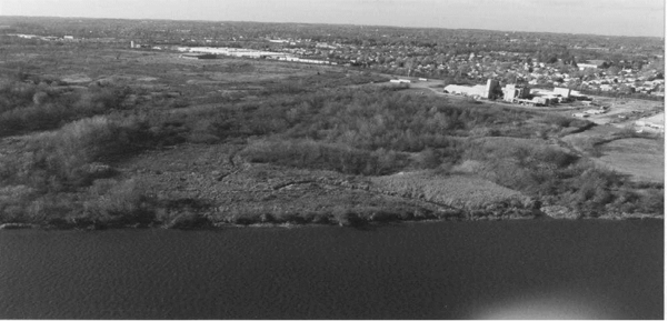
Figure 2. North Wetland - Pre-remediation.
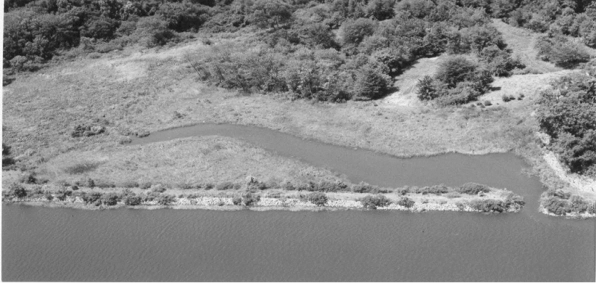
Figure 3. North Wetland - Post-remediation.
A.50.5.2 South Landfill Area and South Wetlands
Final selected remedy: Excavation, restoration and monitoring
The South Wetlands remediation and restoration were similar to that of the North Wetlands in that DuPont proactively included the following basic components that were above and beyond the ROD requirements in an attempt to optimize functions and values that could be provided by the restoration site (DuPont Environmental Remediation Services, 1997b):
- sediment excavation to a greater depth and backfilling
- hummock construction and planting
- sediment stabilization with erosion matting
- removal of berm
- South Pond enhancement
- phragmites control program
The remedy for the south wetland was modified during remedial design to enhance the cleanup based on DuPont’s desire to construct the best possible wetland. The enhancements included a significant reduction on the site-specific sediment cleanup criteria for the south wetlands, excavating deeper, heavily contaminated sediments that were discovered in the remedial design, increasing the biodiversity of the wetland, and removal of the berm (mentioned above). The performance standards for the ROD were modified to accomplish these changes. During the remediation of the South Wetlands, portions of the berm up to 11 ft in depth were removed to create hummocks. Berm removal resulted in the opportunity to open the South Pond to tidal influence. The South Pond did not require remediation; however, 2 ft were excavated to remove fine-grained sediments. It also was re-contoured to provide a more gradual intertidal zone that was vegetated with emergent vegetation forms. Drainage features were added to facilitate sufficient water storage between high-tide cycles and develop more direct access to improve the tidal exchange throughout the South Wetlands. Tidal habitat was significantly improved by the removal of additional materials from the wetlands, berm, and South Pond areas, in conjunction with the enhancement of drainage features.
The south landfill cleanup plan included a barrier system to physically separate the waste material from the environment. The barrier system included a slurry wall that was placed parallel with the Christina River. In addition, the south landfill was capped using a geosynthetic clay liner and a high density polyethylene membrane. The membrane capA covering over material (contaminated sediment) used to isolate the contaminants from the surrounding environment. extended down the riverbank to the low mean tideline. The riverbank was then covered with armor stone. Sediment samples were collected in the Christina River along the south landfill to serve as a baseline for future monitoring to ensure that heavy metals from the south landfill do not contaminate the river sediments.
A total of 37,000 yd3 of contaminated sediments were removed from a 6.5 acre wetland and pond area. The wetlands were rebuilt/restored and an additional 1.7 acres of wetlands were created by removing 20,000 yd3 of contaminated soil from a berm. Approximately 57,000 yd3 of material were disposed of in the south landfill.
Sediment criteria were as follows: cadmium – 35 mg/kg, lead – 670 mg/kg, and zinc – 2,000 mg/kg. These concentrations were to be protective of human recreational exposures
Why the remedy was selected: Prevent unacceptable impacts to environmental receptors.
As with the North Wetlands, DuPont exceeded the 1-foot sediment removal depth required by the ROD and removed all sediment down to the marsh clay deposit layer (approximately 2 ft) to eliminate any potential future concerns of recontamination from sediments left in place. Portions of the berm, up to 11 ft in depth, were removed to create hummocks. The creation of the hummocks increased cover type diversity and vertical stratification of the wetlands.
Erosion matting increased sediment stabilization and proved effective during severe storm events. The matting also facilitated the development of a substrate for colonization by benthic invertebrate fauna and vegetation.
Removal of the berm resulted in the opportunity to open the South Pond to tidal influence. The South Pond did not require remediation; however, it was excavated 2 ft to remove fine-grained sediments. It was also re-contoured to provide a more gradual intertidal zone that was vegetated with emergent vegetation. Drainage features were also added to facilitate sufficient water storage between high-tide cycles and develop more of a direct access to improve the tidal exchange throughout the South Wetlands.
Control of Phragmites and other invasive species helped promote colonization of the marsh habitat by a more diverse assemblage of native plants. A diverse plant assemblage provides for better animal forage and enhances the functional capacity of the restored marsh to support wildlife.
Removal of the additional materials from the wetlands, berm, and South Pond areas, in conjunction with the enhancement of drainage features, allowed for a significantly improved tidal habitat than previously was present. The increased tidal water storage and the daily inundation of the wetlands at high tide and the water exchange in the South Pond has increased the functional capacity for benthos, fish, birds, and wildlife. These physical changes along with the Phragmites control program also minimized the amount of Phragmites in the South Wetlands.
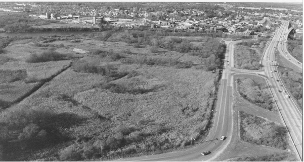
Figure 4. Pre-remediation (looking from the south).
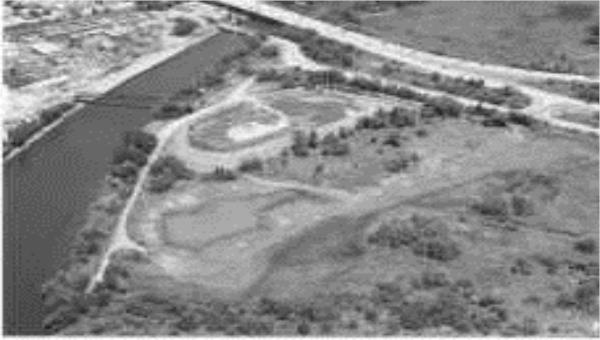
Figure 5. Post-remediation (looking from the southeast).
A.50.5.3 Christina River
Final selected remedy: Dredge and monitoring
Cleanup activities for the Christina River included the dredging of 2.9 acres (one acre along the banks of the north landfill and the CibaSC plant, one acre upstream and one acre downstream of the facility). The Christina River study area consisted of 3.5 miles of river (1 mile upriver of the north drainage way, 0.5 mile along the site, and 2 miles down-river of the site). Sediments contaminated with heavy metals were removed (approximately 11,000 yd3). On-site disposal of the sediments occurred in the south landfill, and restoration of the dredged areas was conducted. The restoration of dredged areas included backfilling all of the dredged areas and replanting the intertidal zones at the up- and downgradient areas. Sheet piling was used to prevent the migration of contaminated sediments during the wet dredging operations.
The pre-design delineation investigation was completed between March 1995 and February 1996. EPA approved the delineation in August 1996. Based on these data, three areas requiring remediation were identified. Subsequent confirmation sampling for the remedial areas was conducted and submitted to EPA in October 1996. Additional sediment sampling was completed in December 1997 to support the remedial design. Excavation began in 1998, and restoration was completed in 1999. The remedy for the Christina River was modified during the remedial design in several ways that greatly enhanced the cleanup. Once the contaminated areas of the river were delineated, it became apparent that there were areas of “marginal” contamination that were relatively small. DuPont proposed lowering the cleanup criteria and dredging these marginal areas thus eliminating the need for the extensive long-term monitoring program that was part of the ROD. As a result, EPA changed the site-specific sediment cleanup criteria for the Christina River. The changes were as follows:
|
Contaminant |
Original Site-Specific Cleanup Criteria |
Revised Site-Specific Cleanup Criteria |
Effective Site-Specific Cleanup Criteria |
Approximate Average Sediment Concentrations after Cleanup |
|---|---|---|---|---|
|
Zinc |
5,600 ppm |
3,000 ppm |
1,500 ppm |
570 ppm |
|
Lead |
1,200 ppm |
700 ppm |
120 ppm |
46 ppm |
|
Cadmium |
60 ppm |
20 ppm |
6 ppm |
1.7 ppm |
Why the remedy was selected: Prevent unacceptable impacts to environmental receptors.
Expected recovery time: NA
Project capital costs: $45,260,000 (includes soil and groundwater remedy costs)
Projected operation and monitoring costs: $48,155,000 (includes soil and groundwater remedy costs)
A.50.6 Monitoring Approach
For the north and south wetlands and the Christina River, the operations and maintenance included two inspections each year to monitor success of the plantings, evaluate the density and diversity of the plants, observe wildlife usage, look for erosion, and measure the percent coverage of invasive species.
A.50.6.1 North Wetlands
Remediation activities in the North Wetlands began in 1997 and restoration was completed in 1998. The EPA signed the Remedial Action Completion Report in June 1998. Maintenance and monitoring of the restoration began in June 1998 in accordance with the approved Maintenance and Monitoring Plan (DuPont CRG, 1998). The North Wetlands has passed its sixth year post restoration (1998 to 2003). Success metrics for vegetative cover, sediment stabilization, and invasive species were met within 3 years post-restoration. The site exceeds regional reference locations in terms of vegetative diversity and use by wildlife. Extensive data and information on the wetlands restoration progress has been collected from 1998 to the present as part of the annual and routine monthly inspections outlined in the Maintenance and Monitoring Plan (DuPont CRG, 1998) and Addendum (DuPont CRG 2002a).
Successful restoration of the North Wetland has vastly improved the functional capacity of this wetland to support fish communities in the Christina River. Fisheries surveys were conducted in 1999, 2001, and 2002 and have proven that the North Wetland supports a healthy, diverse fish community comprised of freshwater and estuarine species. The installation of a water control structure has successfully created a tidal open water habitat that maintains a continuous pool of water within the North Wetland and also allows for tidal flushing back into dense and diverse marsh vegetation. The increased (and increasing) complexity of this habitat type within the marsh provides niches for fish from all life stages (mature, mature spawning, juvenile, young-of-the-year, and larval fish). Currently, fisheries survey results suggest that one of the North Wetland’s primary functions is a fish community nursery area. The collection of fishes from all life stages indicates that the aquatic habitat also functions as spawning and feeding grounds for numerous species. Overall, the abundance and structure of this fish community clearly demonstrate that the North Wetlands have been successfully restored to a level where the aquatic habitat now functions as an integral part of fisheries development and recruitment within the Christina River Watershed. (DuPont CRG, 2002a).
The well-established fish and benthic communities provide a substantial food source for birds that now frequent the area. Historically, the low quality habitat provided little niche space that resulted in low overall species richness. Use of the wetlands has increased over time and the bird community has become an integral part of the complex wetland food web. Both migratory and resident bird species that fill various trophic levels have been observed including piscivores (such as great egrets and osprey), invertivores (such as American robins and swallows), and granivores (such as red-winged blackbirds and sparrows). Many of these birds rely on the wetlands for foraging, nesting, breeding, and shelter.
A.50.6.2 South Landfill and Associated Wetlands
Remediation activities and restoration were completed in 1998 for the South Wetlands. The EPA signed the Remedial Action Completion Report in January 1999. Maintenance and monitoring of the restoration began in January 1999 in accordance with the approved Maintenance and Monitoring Plan (DuPont CRG, 1999). The South Wetlands has passed its fifth year post-restoration (1999 to 2003). Success metrics for vegetative cover, sediment stabilization, and invasive species were met within the first three years post restoration. As with the North Wetlands, the South Wetlands exceeds regional reference locations in terms of vegetative diversity and use by wildlife. Extensive data and information on the wetlands restoration progress has been collected as part of the annual and routine inspections as outlined in the Maintenance and Monitoring Plan (DuPont CRG, 1999) and Addendum (DuPont CRG, 2002a).
Successful restoration of the South Wetland has vastly improved the functional capacity of this wetland to support fish communities in the Christina River. The drainage features continue to promote tidal flushing of the South Wetlands and water exchange within the South Pond. Fisheries surveys conducted annually in 2000, 2002, and 2003 have indicated that the South Wetland supports a healthy, diverse fish community comprised primarily of freshwater species with occasional use by estuarine species. The removal of dense stands of Phragmites, coupled with the restoration of drainage systems in the wetland have successfully created a tidally contiguous, open water habitat that regularly inundates the surrounding vegetation. The increased diversity of aquatic habitat types currently accessible to fish communities has provided niches for numerous species from all life stages (mature, mature spawning, juvenile, young-of-the-year, and larval fish). The presence of these various life stages indicates that the functional capacity of the South Wetland now includes spawning, feeding, and rearing grounds for fish communities. In addition, this wetland has continued to develop, attracting and supporting new species including obligate wetland fish such as the eastern mudminnow (Umbra pygmaea), collected in 2003. Overall, the abundance and structure of this fish community clearly demonstrates that the South Wetlands have been successfully restored to a level where the aquatic habitat now functions as an integral part of fisheries development, diversity, and recruitment within the Christina River Watershed.
The dramatic change in vegetative cover types has resulted in habitat opportunities for a variety of migratory and resident bird species. In addition, the well-established fish and benthic communities provide a substantial food source for birds that now frequent the area. Where the original monotypic stand of Phragmites provided poor bird habitat, the current habitat provides space for all trophic levels of birds. Many of these birds rely on the wetlands for foraging, nesting, breeding, and shelter.
A.50.6.3 Christina River
Maintenance and monitoring began in September 1999 in accordance with the approved Maintenance and Monitoring Plan. The EPA signed the Remedial Action Completion Report in February 2000. All success metrics established for the Christina River Area were met within the first few years of monitoring. All areas remained stable with increases in vegetative cover and species richness. Natural recruitment of plants resulted in the successful establishment of a diverse emergent plant community. In 2003, DNREC activities on the Christina River resulted in the disruption of the down-river area. A 10-foot wide mosquito control ditch was cut through the restoration site. Because this action was undertaken by the state, no corrective actions by DuPont was required. However, EPA is requiring DNREC to sample in the dredged area to ensure that there is no contamination in the upper several feet of sediment.
In order for the remedy at the river to be protective in the long-term, a determination must be made as to whether sediment contamination found in deeper sediment at an adjacent site (Koppers, DE, Superfund Site – also a case study in this document) and a nearby potential wetlands mitigation site is from DuPont-Newport Superfund Site and, if so, if it poses a risk to human health and the environment.
A.50.7 Site References
USEPA. 1993. Record of Decision (ROD) for the DuPont-Newport Superfund Site. USEPA. August 26, 1993.
USEPA. 2010 Third Five-Year Review Report, E.I. DuPont, Newport Superfund Site; Newport, Delaware. Mach 31, 2010.
DuPont CRG, 1998, DuPont CRG. 1998. Monitoring and Maintenance Plan – North Wetlands, Newport Superfund Site, Newport, Delaware.
DuPont CRG, 1999, DuPont CRG. 1999. Monitoring and Maintenance Plan – South Wetlands, Newport Superfund Site, Newport, Delaware.
DuPont CRG 2002a, DuPont Corporate Remediation Group (CRG). 2002a. 2002 Annual Inspection Report – North Wetlands, Newport Superfund Site, Newport, Delaware.
Publication Date: August 2014